


Spain Topo Maps

Spain Topo Maps의 설명
+++ 새로운 GPS 매핑 앱 +++
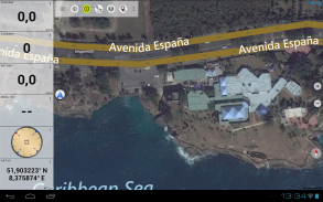
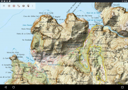
스페인의 최적의 지형도와 공중 이미지에 액세스 할 수있는 야외 / 오프라인 GPS 네비게이션 응용 프로그램을 사용하기 쉽습니다.
발레 아레스 제도와 카나리아 제도 포함
++ 오프라인 사용을 위해 필요한 PRO 기능! ++
휴대 전화 / 태블릿을 야외 GPS로 전환하여 휴대 전화 없이도 오지로 여행하십시오. 이 응용 프로그램은 GPS 핸드 헬드에서 알 수있는 것과 유사한 매핑 옵션을 제공합니다.
무료지도 레이어 포함 :
• 스페인 Topo지도 : Mapa Topográfico Nacional 1 : 50.000 & 1 : 25.000 (IGN MTN25 & MTN50)
• IGN 기본지도 : Base Topográfica Nacional 1 : 25.000 (BTN25 & BCN25)
• Spain Imagery : 고해상도 공중 이미지. Plan Nacional de Ortofotografía Aérea (PNOA) 계획
• 카탈로니아 토포지도 : 카탈로니아의 고해상도 지형도
• 토지 등록 맵 : Cartagrafía Catastral
OpenStreetMaps :이 crowdsourced 맵은 다른 맵 레이어에 매우 유용합니다. 많은 고유 한 기능을 포함합니다.
• OpenCycleMaps :이지도는 자전거 여행 계획에 이상적입니다.
• ESRI 지형도
• ESRI 공중 이미지
• ESRI 거리지도
• Google 로드맵 (온라인 액세스 전용)
• Google 위성 이미지 (온라인 액세스 전용)
• Google 지형지도 (온라인 액세스 전용)
• Bing Road Map (온라인 액세스 전용)
• Bing Satellite 이미지 (온라인 액세스 전용)
• 지구의 밤
• 산 경사면 오버레이
실외 항법을위한 주요 특징 :
• 웨이 포인트 생성 및 편집
• GoTo-Waypoint-Navigation
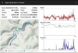
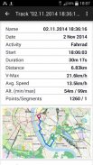
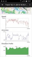
• 트랙 레코딩 (속도, 고도 및 정확도 프로파일 포함)
• 거리계, 평균 속도, 베어링, 고도 등을위한 필드가있는 Tripmaster.
• GPX / KML / KMZ 내보내기
• 검색 (placenames, POI, 거리)
지도보기 및 Tripmaster의 맞춤식 데이터 필드 (예 : 속도, 거리, 나침반, ...)
• 웨이 포인트, 트랙 또는 경로 공유 (eMail, Whatsapp, Dropbox, Facebook 등)
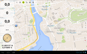
• 위도 / 경도, UTM 또는 MGRS / USNG (군용 그리드 / 미국 내셔널 그리드) 좌표 표시
• 통계 및 고도 프로필을 사용하여 트랙 기록 및 공유
•지도 회전 (Track Up & North Up)
•지도를 길게 클릭하여 고도 가져 오기
• 트랙 재생
• 그리고 더 많은 ...
사용 가능한 프로 기능 : (인앱 구매를 통해 제공되는 프로 기능)
• 오프라인 사용 - 셀 범위가 필요하지 않습니다.
• 오프라인 사용을위한지도 타일의 Easy + Fast 대량 다운로드 (Google 및 Bing 맵용이 아님)
• 경로 생성 및 편집
• 경로 탐색 (지점 간 탐색)
• GPX / KML / KMZ 가져 오기
• 무제한 웨이 포인트 및 트랙
• 다른지도 타일 서버 추가
• 광고 없음
오프라인 사용 :
모든 보이는지도 타일은 캐시에 보관됩니다. 큰 영역을 캐시하려면 Pro 기능을 구입해야합니다.
하이킹, 자전거 타기, 캠핑, 등산, 승마, 스키, 카누, 사냥, 오프로드 4WD 둘러보기 또는 검색 및 구조 (SAR)와 같은 야외 활동에이 탐색 앱을 사용하십시오.
WGS84 데이터로 경도 / 위도, UTM 또는 MGRS / USNG 형식의 사용자 정의 웨이 포인트를 추가하십시오.
GPX 또는 Google 어스 KML / KMZ 형식의 GPS- 웨이 포인트 / 트랙 / 경로 가져 오기 / 내보내기 / 공유
셀 서비스가 제공되지 않는 지역의 프리 맵 데이터를 미리로드하십시오 (Pro 기능!).
spainmaps@atlogis.com에 대한 의견 및 기능 요청
다른 야외 탐색 앱 (https://play.google.com/store/search?q=atlogis)을 살펴보세요.
+++ 우리는 사용자 활동을 추적하거나 사용자 데이터를 수집하지 않습니다! +++
Spain Topo Maps - 버전 7.8.0
(08-05-2025)
Spain Topo Maps - APK 정보
APK 버전: 7.8.0패키지: com.atlogis.spainSpain Topo Maps의 최신 버전
다른 버전들


동일 카테고리의 앱


